Weather
Brian Head, Utah
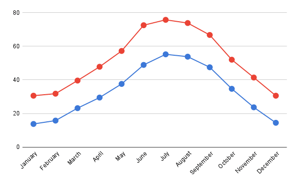
With a mean annual snowfall of 355.9 inches or 9.04 metres, Brian Head is one of the snowiest inhabited places in the United States, receiving over 5 feet or 1.5 metres more snow than Valdez, Alaska. Snow depth remains at 7 inches or 0.18 metres as late as June, with the average monthly depth being around 75 inches or 1.91 metres in March and April, with extremes of over 130 inches or 3.30 metres.
The very heavy snow does not ease until May when temperatures begin to rise above 50 °F or 10 °C, and May and June are also the driest months. Summer weather in Brian Head is influenced by the tail end of the North American Monsoon, which provides frequent thunderstorms in July and August. After the monsoon retreats, temperatures rapidly fall during September and October, when snow cover is permanently re-established.
Hatch, Utah
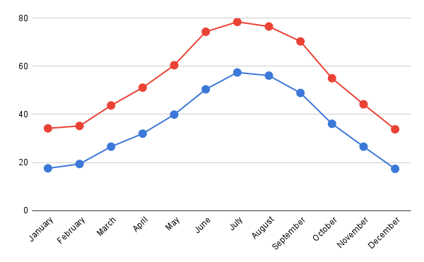
Climate in this area has mild differences between highs and lows, and there is adequate rainfall year-round. July is the warmest month, with an average high-temperature of 79.3°F (26.3°C) and an average low-temperature of 54.3°F (12.4°C). The month with the most rainfall in Hatch, Utah, is July when the rain falls for 13 days and typically aggregates up to 1.5″ (38mm) of precipitation.
Bryce Canyon, Utah
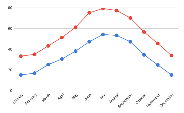
Bryce Canyon National Park has a continental climate with warm, dry summers. The national park is located in southwestern Utah about 50 miles (80 km) northeast of and 1,000 feet (300 m) higher than Zion National Park.[9][5] The weather in Bryce Canyon is therefore cooler, and the park receives more precipitation: a total of 15 to 18 inches (380 to 460 mm) per year.[10][7] Yearly temperatures vary from an average minimum of 9 °F (−13 °C) in January to an average maximum of 83 °F (28 °C) in July, but extreme temperatures can range from −30 to 97 °F (−34 to 36 °C).
Barker Reservoir, Utah
Aquarius Plateau, Utah
Boulder, Utah
Escalante, Utah
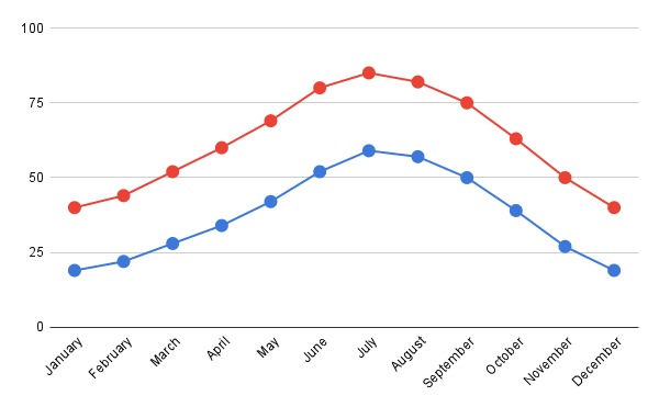
Escalante has a cold semi-arid climate. Average yearly precipitation is 10.56 in (268 mm) with most precipitation occurring from July to October with a peak in August of 1.64 in (42 mm). The driest month is June with an average of 0.40 in (10 mm). Snow falls mainly from November to April with trace amounts occurring in October. The average yearly snowfall total is 25.5 in (65 cm).
Daytime high to nighttime low temperature ranges are approximately 26 °F (14 °C) in the winter months to 37 °F (20 °C) in midsummer. July has the warmest average high temperatures at 92.3 °F (33.5 °C) while January has the coldest average low temperatures at 18.8 °F (−7.3 °C).
